

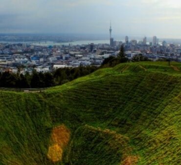
 Auckland has several notable hills – Mt Victoria (Takarunga), Mt Eden (Maungawhau), One Tree Hill (Maungakiekie), Mt Wellington (Maungarei), and more.
It also has some pretty neat water features, like Mangere Lagoon, Panmure Basin, or Lake Pupuke. Then looking East is the scenic Rangitoto island. All of these are just a few of the 53 known volcanic centres in the Auckland Volcanic Field, which is classified as still active – future eruptions will likely occur but there is currently no activity or unrest. The depth of magma is thought to be around 70-90 km and there are no signs of it moving towards the surface.
A volcanic field is a large region of dozens to hundreds of volcanic features, even reaching well over 1,400 vents, across tens to hundreds of kilometres and all from the same magma system. Most features in these fields produce one eruption (Rangitoto had two), which can last from days to months, or a few years, and this means that each new eruption tends to occur in a new location instead of an existing cone or crater. This means that the existing cones and craters in Auckland will likely not be the site of the next eruption, it will be somewhere else.

Janine Krippner
At most volcanoes we can reasonably assume that an eruption will take place at one of the main craters or at least somewhere on or just below the cone, but in a volcanic field this is much more complex. Our biggest city sprawls across the roughly 20 by 30 square kilometre volcanic field that began erupting around 193,000 years ago.
The last eruption around 600 years ago at Rangitoto was witnessed by people in the area. Eruptions could produce lava flows, ballistics (flying rocks), lava domes, pyroclastic flows (hot, fast flows of ash, gas, and rocks), volcanic ash, volcanic gases, lahars (mudflows), and earthquakes. The eruptions tend to be on the smaller end of the scale, but it doesn’t take a big eruption to be a devastating event when people are nearby, let alone within densely populated areas. In addition, when magma mixes with water (such as lakes, harbours, or groundwater), the eruptions can be more explosive and much more dangerous.
A lot of work is being done to not only understand the volcanic activity in the area, but how it would impact Auckland and beyond, and what actions people and groups can take now to prepare for an eruption. In fact, there are more than 60 years of research in some of these areas. We do this by understanding what volcanoes in Auckland have done in the past, and we also look at other volcanoes around the world. We study how eruptions impact people and infrastructure, such as water mains, roads and electricity.
The next time you visit Auckland, look around you and see how many volcanic cones you can spot.